Understanding of the relative sensitivity of different ecosystems to predicted future environmental changes
Understanding and predicting factors driving species distributions are major challenges for biodiversity management and we are developing and testing spatial analysis techniques to support these aims.
Climate envelopes
These methods are currently widely used to explore climate change impacts on species distributions, but have been criticized on theoretical grounds. Our latest research analyses impacts of climate and other drivers on plant and animal distributions, and is already challenging the appropriateness of the widely-used climate envelopes.
Our test of these methods uses null models of species distributions that retain spatial autocorrelation structure/prevalence,( but not location), applied it to 100 European bird species. We conclude that 2/3 are not strongly related to climate, in contrast to popular scientific assertion, our results challenge this approach underpinning current climate impact research and its application for biodiversity conservation.
This has important implications for management decision-making and policy development in the area of climate change. Beale CM, Lennon JJ & Gimona, A (2008), Opening the climate envelope reveals no macroscale associations with climate in European birds. PNAS, 105 (39), 14908-14912
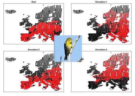
Example of climate envelope test: top left: real distribution of Serin (Serinus serinus) in red; other diagrams show null distribution patterns with the same spatial characteristics as the real distribution, demonstrating the validity of our approach.
Spatial analysis of atlas data
A software tool has been developed to analyse atlas data of species distributions and alpha/beta-diversity patterns. Point process models offer a powerful new suite of techniques for analysis of fine scale plant/animal distributions, and we have developed two new methods for analysing changes between point patterns and used them to analyse upland bird community change. These reveal that several upland birds are moving altitudinally upwards, perhaps in response to changing climate, but our results suggest that changes in moorland habitat may be stronger than climate in determining distribution change.
Measures of climate change
Predicting the nature and impact of climate change on biodiversity has often used climatic means to predict likely patterns of change. Testing climate-related hypotheses for observed change in UK bird biodiversity 1970-1990, using spatial mixed modelling; we found climatic variability to be a better predictor of avian biodiversity, and propose this as a better measure of climate change for this purpose. We also found a significant relationship between spatial and temporal turnover in avian species composition, indicating that spatial turnover is a clue to future compositional change.
Contacts
|
 This site is hosted by The James Hutton Institute